Changing Landscapes
Last Updated on 25th October 2025
Ever since humans first flattened a piece of land for crops or dug out ground for a house, we have made an impact on the landscape.
These changes can remain long after the original use has gone, and the area has reverted to fields or wild land.
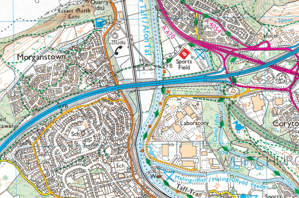
Looking at the area to the North of Cardiff, at Forest Farm, where today the M4/A470 interchange has been built:
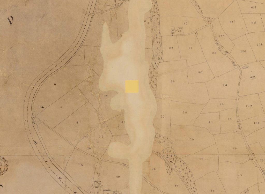
An 1840 tithe map shows an area of farmland on flatish alluvial land sloping down from the steeper ridges of limestone rock towards the river Taff. The Glamorganshire Canal was built in the 1790s to carry goods from the industrial areas in the Valleys to docks in Cardiff, but otherwise this area was still mostly fields. As the canal mainly followed the contours of the land to keep level (other than the occasional lock to increase height), its impact on the landscape was minimal.
It would not be long until various railways appeared. These were built to be as level and straight as possible, and embankments and cuttings were made through the landscape and bridges built to cross existing roads and canals. As the demand for more railways increased to haul more coal to the docks, more lines were built – because the best routes had already been used the later lines, such as the Cardiff Railway, had to weave their way around other lines as well canals and roads.
As the need for canals diminished – railways took much of their traffic – those old canal cuts would either become disused or find new use as a base for more railways.
With the invention of motor vehicles, more traffic came to the roads – the flexibility of motorised traffic being able to deliver literally door-to-door for some goods, combined with the demise of heavy industry – now saw reductions in railways and an increased need for new roads. These would in turn make their own mark on the landscape, occasionally reusing old railways, but more often cutting new cuttings and embankments into the countryside and sometimes obliterating the earthworks of previous transport systems.
Whilst we may seem to revere the earthworks of our ancestors from thousands of years ago, especially where burials had apparently taken place, it is perhaps the case that those remaining possibly do so because they are in places where we haven’t wanted to build anything significant since?
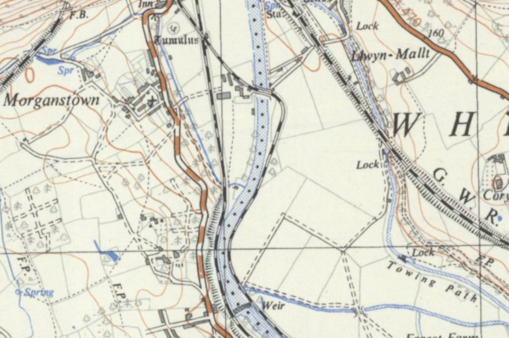
Comparing the 1830-1880 map to a much more recent LIDAR scan of the same area, traces of the canal can still be seen along with the path of the old Cardiff Railway, (which wasn’t built until the early 1900s). However, both are cut across by the embankments built for the M4 and other roads, but despite this the remains of the old earthworks can be seen between the two parallel roads.


Here’s a video I made where I explore the area we are discussing.
The current day map shows a much busier area dominated by major roads and housing, with light industry and sports pitches built over the fields that survived the industrial revolution. It is surprising though, how much of the earlier canal and railway earthworks still remain, although no longer in use.
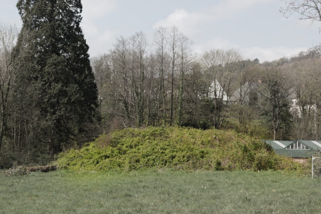
Returning to my earlier comment about historical earthworks; in Morganstown, just across the River Taff from the remains of the canal, the maps show a mound marked with the word ‘Tumulus’. This is the Morganstown Castle Mound, the remains of a medieval Motte and Ditch. According to CADW “The monument is of national importance for its potential to enhance our knowledge of medieval defensive practices. The monument is well-preserved and an important relic of the medieval landscape. It retains significant archaeological potential, with a strong probability of the presence of both structural evidence and intact associated deposits.” This has survived all the industry and landscape changes that have occurred in this area, but sits today, largely ignored, surrounded by a garden centre and sports pitches.
As the A470 heads north, it is built over the canal and some part of the Cardiff Railway – (including an entire railway tunnel at Tongwynlais, which was demolished for the new road) but just to the north of the area shown in these maps, sits an area known as the Taff Gorge, a tight valley where once there were multiple railway lines, a canal, a variety of heavy industries and the main road north from Cardiff. All overlooked by a rebuilt medieval castle created during this period of industry, by a man purported to be (at the time) the richest man in the world. I hope to look into that area for a future article here.
➡ see also my page on the Cardiff railway
References
➡ Plan of the Parish of Whitchurch in the County of Glamorgan from Tithe Maps of Wales at the National Library of Wales
➡ OS Six Inch 1830s-1880s (county layers); OS 1:25,000, 1937-61; LiDAR DTM 50cm-1m and OS Maps Leisure 1:50,000/1:25,000 from Georeferenced Maps National Library of Scotland
➡ The Morganstown Castle Mound at CADW Scheduled Monuments